Best Treks in Patagonia

Overview
Spanning over 1 million sq km, Patagonia stretches across southern Chile and Argentina, hemmed in by the peaks of the Andes to the west and the Atlantic Ocean to the east. The treks are a mix of high alpine and challenging mountain passes, as well as treks at sea level that take you past giant glaciers.
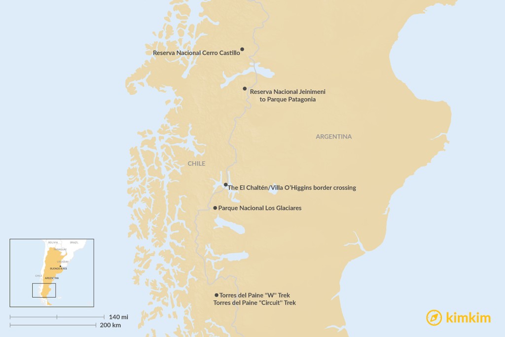
Most visitors to southern Patagonia combine trips to Chile's Torres del Paine National Park with visits to Argentina's Parque Nacional Los Glaciares. Note that direct access to Chile's Parque Patagonia from Argentina, along the wonderfully scenic but little-used RN41 requires a 4WD vehicle.
Expert tip: It's better to pick either northern or southern Patagonia and explore one or the other in more detail than spread yourself too thin by trying to do both with limited time.
Torres del Paine "W'' Trek (Chile)

Arguably South America’s finest national park, the 1124-sq-mile Torres del Paine is overlooked by the granite towers that give the park its name.
The mountains, lakes, vast glaciers and dense forest are easily accessible, thanks to two long-distance hikes, the "W" and the "Circuit." There's good infrastructure on both routes: you can stay in comfortable refugios (lodges), where well-appointed dorms and gourmet meals are available. Alternatively, you can camp all the way along both routes.
The 43 mile (70 km) “W”, resembling the letter that it traces on the map, takes in the park’s three main highlights: Glacier Grey, the French Valley and Las Torres and takes around four days.
The day-hike from Paine Grande to Glacier Grey is relatively gentle; the middle leg up the French Valley is a stiff, steep hike past the hanging Francés glacier to the base of Los Cuernos — the horn-like peaks that are one of the park’s most distinctive features. From the French Valley, a steep descent skirts glacial Lake Nordenskjöld, while the final leg of the “W” ascends the Ascencio Valley. It’s a steep scramble up slippery boulders to reach the small lagoon that reflects the three mighty granite towers.
Expert Tip: All accommodation must be booked weeks or even months in advance due to demand. All refugios and campsites can be booked online.
Torres del Paine "Circuit'' Trek (Chile)

The 70 mile (112 km) “Circuit” (sometimes also referred to as the "O") encompasses the “W” and completes the loop, involving back-country hiking through fields of daisies and dense lenga forest, as well as the challenging ascent to the trail’s highest point — John Gardner Pass, where you see the Glacier Grey and the Southern Ice Field spreading out beneath you. Wildlife sightings are common, from guanacos and hares to the occasional puma.
Chat with a local specialist who can help organize your trip.
Parque Nacional Los Glaciares (Argentina)

The little town of El Chaltén is the starting point for most hikes in the 4511 sq-mile Parque Nacional Los Glaciares, Argentinian Patagonia’s stellar national park. While there are day hikes aplenty, there are several demanding multi-day treks as well. The classic is the three-day, two-night Monte Fitz Roy/Cerro Torre loop that features views of the Mt Fitz Roy incisor 11,302 ft (3445m) as its highlight.
A tougher challenge is the Circuito Los Huemules - a five-day loop that skirts Laguna Toro, climbs up to Paso del Viento and Paso Huemul, rewarding you with unparalleled views of Glaciar Viedma before descending to Lago Viedma.
Finally, accessible only with a guide and requiring a high level of physical fitness, you can try a multi-day trek that starts by the Estancia El Pilar (near the Río Eléctrico) and crosses Glaciar Marconi. This trek involves at least two nights of camping directly on the Southern Icefield, so a four-season sleeping bag is a must. Pack a tent and all supplies necessary for the trek.
Expert tip: After you've hiked to your heart's content in El Chaltén, you can take a bus south of El Calafate (3 hours), the southern gateway to the park, to visit the other unmissable attraction in Los Glaciares: the Perito Moreno Glacier.
Reserva Nacional Jeinimeni to Parque Patagonia (Chile)

Some 35 miles southwest of Chile Chico in Aisén and reachable only by 4WD vehicle, this 622 sq mile reserve consists largely of steppe, punctuated by turquoise highland lakes.
The 3 mile (5 km) Lago Verde trail is the starting point for the four-day, 28 mile (45 km) trek through the Aviles Valley, which connects Jeinimeni to Parque Nacional Patagonia near Cochrane, south along the Carretera Austral (central highway). The trek requires wilderness experience and good navigational skills since there are several river crossings involved and the trail is not terribly well-marked.
The trek ends at the Stone House campground in Parque Patagonia — a rehabilitated 428 sq mile former estancia (ranch) where the steppe, highland lakes and forests and mountains are once again an important wildlife corridor. From the Stone House campground, it’s a further 16 miles (25 km) hike west along the road to the park headquarters. There are plans to link Parque Nacional Patagonia to Reserva Nacional Tamango, near the town of Cochrane, giving scope to an even longer trek.
As of January 29, 2018, Reserva Nacional Jeinimeni, Parque Patagonia and Reserva Nacional Tamango will be combined into one vast, 1015 sq mile national park, 1.5 times larger than Torres del Paine - Chile's best-known and most-visited national park. During the 15-month transition period, the three park sectors will still be known by their old names.
The El Chaltén/Villa O’Higgins border crossing (Argentina/Chile)

There's no road connecting Argentina’s legendary Ruta 40 with Chile’s equally legendary Carretera Austral (Southern Highway). Until one is built, the quickest way to get from one to the other is on foot across the border.
From El Chaltén, get a ride to Lago del Desierto and then either take a boat across the lake or hike through dense forest for 7 miles (12 km). Get stamped out of Argentina, then continue through lenga forest through no man's land until you reach a sign welcoming you to Chile. From the welcome sign, a gravel road gently winds its way down to the vast, glacial Lago O’Higgins.
The trail from the Argentine border post to the Chilean border post at Candelario Mancilla is a distance of 14 miles (22 km). You may have to overnight there, either camping or in one of a handful of rooms, before being picked up by boat the following day and taken to Villa O’Higgins via the vast, glacial Lago O’Higgins. Since the boat is weather-dependent, bring extra food supplies in case you’re stranded for a day or two.
Reserva Nacional Cerro Castillo (Chile)

Home to the elusive huemul deer, this 1118 sq mile mountain reserve has the glacier-flanked, needlepoint basalt spires as its centerpiece and little in the way of hiker traffic. If you take on the challenge of the 25 mile (40 km), four-day Sendero Cerro Castillo, you’re likely to have the forest and lagoons all to yourself.
The trek starts at the Km75 marker of the Carretera Austral, at the north end of the reserve, and follows the Rio La Lima through dense forest, with the gorgeous Laguna Cerro Castillo and glacier views en route, before descending to Villa Cerro Castillo, a picture-perfect village nested amid meadows and mountains. The 4757 ft (1450 m) pass is the main challenge, along with poor trail markings; backcountry camping is the only accommodation option.


